
位置之间的路线信息和公里计算
从哪里
到哪里
Strenči 和 Amata 之间有多少公里和小时?
驾车
1 小时 41 分钟
102.98 公里
群发短信、群发短信服务、群发短信: Strenči - Amata
购买短信套餐: Strenči - Amata
- 无设置成本
- HTTPS 安全网关
- DLT 合规性
只需向账户添加金额 钱包并支付每条短信费用。
通过此平台进行的所有捐赠将用于为非洲有需要的儿童提供食物、衣物和生活支持。
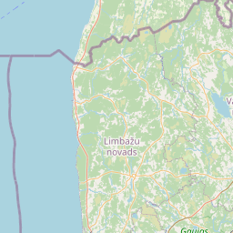
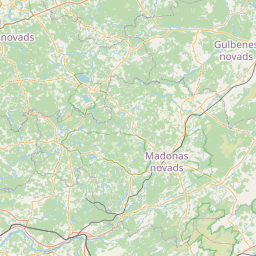
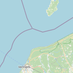

Strenči Amata 的路线
您可以使用实时地图。地图允许您查看行程中的替代路线。根据实时交通状况重新计算预计到达时间,帮助您了解交通的影响。您可以通过“Google 导航”或“Yandex 导航”按钮切换到导航,并获得实时路线指导。
检查您计划旅行当天和时间的天气预报非常重要。这可以帮助您为雨天或其他不利天气条件做好准备。要查看 Strenči 或 Amata 的 5 天天气预报,点击这里。
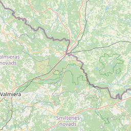
Strenči Amata 的路线
Start: N 57.62081, E 25.80519
End: N 56.99387, E 25.26275
驾车: 102.98 公里
Duration: 1 小时 41 分钟
1.
Head west on Egļi–Oliņas–Bērzs (V260)
(1.09 公里)
2.
Turn left onto A3
(6.15 公里)
3.
Enter the traffic circle and take the 2nd exit onto Valkas iela (A3)
(0.02 公里)
4.
Exit the traffic circle onto Valkas iela (A3)
(0.42 公里)
5.
Continue onto Rīgas iela (A3)
(16.93 公里)
6.
Continue onto Valkas iela
(0.93 公里)
7.
Turn left onto Tērbatas iela (P17)
(0.51 公里)
8.
Enter the traffic circle and take the 2nd exit onto Tērbatas iela (P17)
(0.04 公里)
9.
Exit the traffic circle onto Tērbatas iela (P17)
(0.58 公里)
10.
Continue left onto Lāčplēša iela (P17)
(0.18 公里)
11.
Continue slightly right onto Rīgas iela (P17)
(0.16 公里)
12.
Enter Rīgas iela and take the 2nd exit onto Cēsu iela
(0.06 公里)
13.
Exit the traffic circle onto Cēsu iela
(0.41 公里)
14.
Enter the traffic circle and take the 2nd exit onto Cēsu iela (P20)
(0.08 公里)
15.
Exit the traffic circle onto Cēsu iela (P20)
(0.79 公里)
16.
Turn left to stay on Cēsu iela
(0.99 公里)
17.
Make a slight right onto Cēsu iela
(0.70 公里)
18.
Enter the traffic circle and take the 2nd exit onto P20
(0.11 公里)
19.
Exit the traffic circle onto P20
(14.82 公里)
20.
Turn right to stay on Valmiera — Cēsis — Drabeši (P20)
(9.69 公里)
21.
Turn left to stay on Valmiera — Cēsis — Drabeši (P20)
(1.98 公里)
22.
Enter Priekuļu aplis and take the 2nd exit onto Valmiera — Cēsis — Drabeši (P20)
(0.04 公里)
23.
Exit the traffic circle onto Valmiera — Cēsis — Drabeši (P20)
(2.13 公里)
24.
Enter the traffic circle and take the 2nd exit onto Valmiera — Cēsis — Drabeši (P20)
(0.05 公里)
25.
Exit the traffic circle onto Valmiera — Cēsis — Drabeši (P20)
(4.31 公里)
26.
Turn left onto Drabeši — Līvi (V293)
(2.95 公里)
27.
Turn right onto A2
(1.02 公里)
28.
Turn left onto Ērgļi — Drabeši (P31)
(7.78 公里)
29.
Continue onto Cēsu iela (P31)
(0.74 公里)
30.
Continue onto Nītaures iela (V316)
(0.16 公里)
31.
Continue onto Nītaure - Rencēni (V316)
(15.04 公里)
32.
Turn right onto Garkalne — Alauksts (P3)
(1.42 公里)
33.
Make a sharp left onto Augšlīgatne — Skrīveri (P32)
(10.44 公里)
34.
Make a slight left onto Jaunpils iela (V60)
(0.25 公里)
35.
You have arrived at your destination
(0.00 公里)
:
随机地点
Gabon 的距离计算
Woleu-Ntem - Ogooué-Ivindo Woleu-Ntem - Nyanga Woleu-Ntem - Haut-Ogooué Woleu-Ntem - Estuaire Woleu-Ntem - Ogooué-Maritime Woleu-Ntem - Ogooué-Lolo Woleu-Ntem - Moyen-Ogooué Woleu-Ntem - Ngounié Ogooué-Ivindo - Nyanga Ogooué-Ivindo - Haut-Ogooué Ogooué-Ivindo - Estuaire Ogooué-Ivindo - Ogooué-Maritime Ogooué-Ivindo - Ogooué-Lolo Ogooué-Ivindo - Moyen-Ogooué Ogooué-Ivindo - Ngounié Nyanga - Haut-Ogooué Nyanga - Estuaire Nyanga - Ogooué-Maritime Nyanga - Ogooué-Lolo Nyanga - Moyen-Ogooué Nyanga - Ngounié Haut-Ogooué - Estuaire Haut-Ogooué - Ogooué-Maritime Haut-Ogooué - Ogooué-Lolo Haut-Ogooué - Moyen-Ogooué Haut-Ogooué - Ngounié Estuaire - Ogooué-Maritime Estuaire - Ogooué-Lolo Estuaire - Moyen-Ogooué Estuaire - Ngounié Ogooué-Maritime - Ogooué-Lolo Ogooué-Maritime - Moyen-Ogooué Ogooué-Maritime - Ngounié Ogooué-Lolo - Moyen-Ogooué Ogooué-Lolo - Ngounié Moyen-Ogooué - Ngounié